We spent a week in Helena, Montana, visiting my cousins and finishing the final preparations for our trip north. We took care of the last few RV and truck maintenance items on our list. We finished the drawers for our new pantry. We did a $600 resupply shopping trip in the hopes that we can avoid paying significantly higher prices in Canada/Alaska for canned and dry goods that are easy to transport and won’t go bad. We finally broke out the Milepost, a guide with mile-by-mile descriptions of what we’ll find along the major routes through Canada and Alaska, and started studying. We were about as ready as we could be, and we were itching to get on the move.
Glacier National Park
We wanted to visit Glacier National Park when we came through the area last fall, but due to all of the wildfires, sections of the park were closed and visibility wasn’t great. It didn’t seem like the best time to visit, so we postponed. May isn’t really the best time to visit either since Going-to-the-Sun Road, the main route that traverses the park, doesn’t fully open until late June or early July due to snow. We decided to make a quick stop anyway, though, since we’d be going right by.
McDonald Creek which follows Going-to-the-Sun Road down from the mountains and into Lake McDonald

Lake McDonald

Lake McDonald
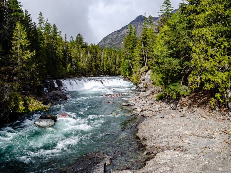
McDonald Creek
It turned out better than planned. Going-to-the-Sun Road might be closed to vehicles, but while plowing is in progress, they allow hikers and bikers to use all of the plowed sections. We took our bikes and traveled along the 6 miles of road that were clear of snow but still closed to vehicles. It was an incredible ride. We passed a few other people on our way, but for the majority of the ride, it was just us, alone on one of the most scenic drives in the country.

Going-to-the-Sun Road

Near Packer’s Roost along Going-to-the-Sun Road. This was as far as we could ride.

Going-to-the-Sun Road

Going-to-the-Sun Road

Going-to-the-Sun Road with nobody in sight
Of course, we couldn’t make it far enough along to actually see any glaciers, and most of the big, expansive overlooks were packed in snow, too, but we weren’t complaining.
We also hiked to Avalanche Lake, one of the park’s most popular hikes. The area was named by one of the park’s early explorers who noted all of the avalanches that happened in the valley. It’s still true today, and there were many downed trees along the path from avalanches that occurred in the area. The lake itself sits at the foot of two large mountains, and it’s fed by the Sperry Glacier. It was a beautiful area and would be a great place to spend an entire afternoon.

Many trees were downed due to avalanches in the area

Avalanche Creek rushing down the valley from the Avalanche Lake to McDonald Creek

Avalanche Lake
Border Crossing
We crossed the border into Canada at Roosville, British Columbia, near the west entrance to Glacier National Park. It was about as easy as a border crossing could be. We crossed mid-day on Wednesday, and we were the only vehicle there. They asked us four total questions:
- Where are you going?
- How long will you be there?
- Do you have any alcohol or tobacco?
- Do you have any weapons?
We did have alcohol, but we’re under the limit you’re allowed to bring, so it wasn’t a problem. On we went.
Just across the border driving into Canada

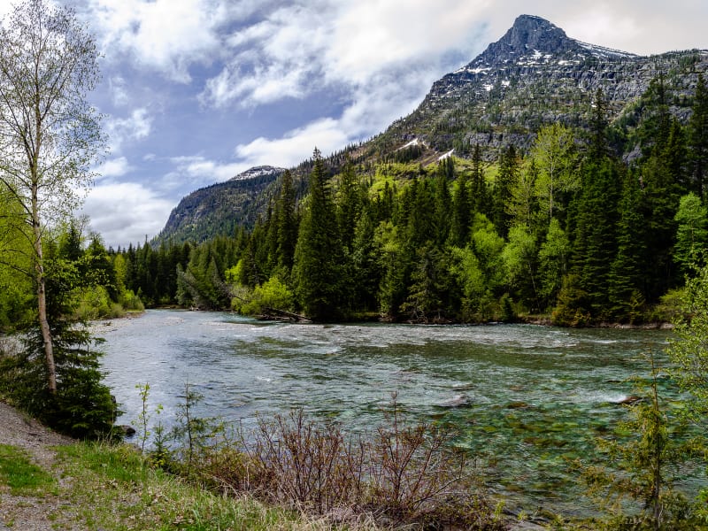
Further along our drive toward Kootenay National Park
The original plan was to stop at Radium Hot Springs for the night. We found a boondocking spot in town, and the hot springs are supposed to be nice; however, since the border crossing was faster than expected, and we were making generally good time anyway, we decided to push on and get to Banff National Park a day early.
Kootenay National Park
Our route took us through Kootenay National Park which, along with Banff, Jasper, and Yoho, form the larger Canadian Rocky Mountains Parks World Heritage Site. Radium Hot Springs was our only planned stop within the park, and since we were skipping that, we just passed through. Most of the major stops within the park were closed anyway since it was a bit early in the season.

Driving into the valley that runs through Kootenay National Park

Views along the drive

More views along the drive
The drive was still beautiful, though. You drive through a steep canyon and climb through a mountain pass before descending into a long valley. Stopping was not allowed on this entire stretch due to high bear activity in the area. We saw three black bears along the road, but we didn’t manage to snag any pictures since we weren’t really prepared and couldn’t stop to do so. After the ‘No Stopping’ zone ended, though, we saw a herd of mountain goats along the road and were able to get some pictures.

A herd of mountain goats in the park

Mountain goats!

Mountain goats!

A baby mountain goat!
After descending from the first mountain pass, you follow the valley for about an hour and then cross another mountain pass that drops you near Lake Louise in Banff National Park.
Banff National Park

The drive as we entered Banff National Park. The bridge in the distance is for animal crossings.
We camped at the Lake Louise Overflow Campground. The main campground wasn’t full, but the overflow was much cheaper. It also happened to be where two of our Xscaper friends, Margot and Michael, were camping.

Checking out Lake Louise with Margot and Michael
We spent three days in Banff with them. Unfortunately, all three days had pretty terrible weather. We had cloudy skies and rainy days, but we did manage to find a few breaks in the weather to check out some nearby sights.

There was a great nearby trail that followed along Bow River
We visited Lake Louise, one of the most iconic lakes in the park. It was still mostly under ice, but the area was still beautiful.

Lake Louise. From what we heard, a few days later, a lot of the ice was gone.

Lake Louise
We also hiked to nearby Mirror Lake, a stop on the way to Lake Agnes. Lake Agnes is the normal destination, and when the summer season is in full swing, there is a teahouse on the lake that you can visit. It was too early for that now, though. The trail to Mirror Lake was still snow and ice covered for most of the hike, and the park website listed it as “Not Recommended,” but a ranger told us it was doable. After Mirror Lake, though, you pass through multiple avalanche zones to reach Lake Agnes. We did see people hiking that way anyway, but it was strongly recommended to not go, so we turned around at that point.

The snow and ice covered trail to Mirror Lake

There were great views of the mountains along Lake Louise from the trail

The Big Beehive overlooking Mirror Lake

A warning sign at Mirror Lake advising us against traveling further
We also took a rainy trip to Moraine Lake, another iconic lake in the park. It was pretty in the snow and fog, and I can only imagine how great it is when the turquoise blue water is visible under sunny skies. We’ll be back for this.

Moraine Lake
Icefields Parkway
The Icefields Parkway, connecting Banff and Jasper National Parks, is regularly ranked as one of the most scenic drives on the planet, and it was a must-see on our trip north.

Starting the drive along the Icefields Parkway

Snowy mountains and glaciers lined the road

Bow Lake

Peyto Lake

Driving into the valley past Peyto Lake
The road runs parallel to the continental divide as it winds through the rocky mountains. There are over 100 glaciers along the route, and there are many glacial lakes as well. We stopped to see Peyto Lake, Bow Lake, and a few others on our way.

Another lake along the drive

An overlook toward one of the mountain passes originally used by the first people in the area. It’s one of the lowest undeveloped passes in the rockies.

Had to get a selfie at some point along the drive!

An overlook near one of the highest points along the drive
We also stopped at the Columbia Icefield Discovery Center which had great exhibits on the Columbia Icefield, the largest icefield in the Rockies. The icefield isn’t accessible, but we hiked to the Athabasca Glacier, one of the six glaciers that the icefield feeds. There were signs all along the hike showing where the end of the glacier had been. Less than 40 years ago, it would have reached the parking lot. About a century ago, it was all the way out near the visitor center. All along the hike, you could see scrape marks in the rocks from when the glacier moved over the area.

Panorama of the Athabasca Glacier and Dome Glacier from the Columbia Icefield Discovery Center

Mount Snow Dome and the Dome Glacier, another glacier fed by the Columbia Icefield

Hiking to the toe of the Athabasca Glacier

Most of the rocks in the area had large scratches covering them. They were created when the glacier moved over the rocks.
Jasper National Park
We saved a couple days to explore Jasper National Park before continuing north. Jasper is the largest national park in the Canadian Rockies, and together with the other parks in the area, it forms UNESCO’s Canadian Rocky Mountain Parks World Heritage Site. Similar to Banff, it’s known for its rivers, lakes, and mountains.
On our first day in the park, we visited Athabasca Falls. It’s not a very tall waterfall, but the volume and force of the water flowing over were pretty incredible. It’s also quite picturesque with the mountain backdrop.
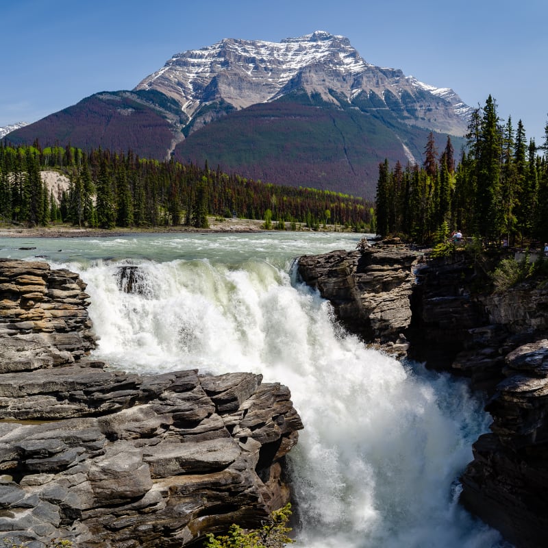
Athabasca Falls
We also hiked the Valley of the Five Lakes. Unsurprisingly, the hike runs through a glacial valley containing five lakes. It was a great hike, and while we weren’t prepared for it, many people came to swim in the largest of the lakes.

Valley of the Five Lakes

First Lake in the Valley of the Five Lakes

Sitting in the red chairs overlooking Third Lake. Parks Canada has set up these chairs around the parks to help promote tourism. They are ‘hidden’ (and included on maps) around the parks and when visitors find them, they are supposed to post a picture to social media. It’s a little silly, but on the other hand, they were nice chairs!
It was a nice hike, but the highlight was definitely when we had our first grizzly bear sighting on the way out! I have a feeling we’ll see a lot more as we travel through Alaska, but there’s something memorable about the first time seeing a particular animal in the wild.

Grizzly Bears!
We ran into this momma and her cub on the Valley of Five Lakes hike in Jasper National Park, and they were right on the trail. Luckily, it was a section of trail that was open and near a field, so they were easy to spot from a distance. There was also quite the crowd already gathered by the time we got there, so we weren’t startled. We were definitely closer than I’d want to be to a Grizzly, but we didn’t have much option given the layout of the trail. Luckily, the bears didn’t seem to mind us at all, and they were able to wander safely off across a field and into the trees.

Momma bear

Her cub
We also had our bear spray with us (the first time we’ve carried it!), just in case it didn’t go as well as it did.
On our second day, we hiked Maligne Canyon. Maligne Canyon was my favorite of the two hikes (correcting for bear sightings, anyway). Half of the loop follows the canyon walls along the river, and there were many impressive waterfalls. The return loop is higher up the mountain and had great views of the surrounding area.

Maligne Canyon

A bridge over the canyon with a waterfall below

The tallest waterfall in the canyon

View from the top of the hill on the hike back out
We also made sure to stop at Miette Hot Springs on our way out of the park. While it started as a natural pool and spring, the water is now fed into a pool complex with larger pools of varying temperatures. It’s located high in a valley and is a beautiful setting to relax in the water.

Miette Hot Springs

Some sheep hanging out in the parking lot at the hot springs
Up Next
Next week, we’ll reach Dawson City, British Columbia, and the start of the Alaska Highway.