West Texas
Big Bend National Park
There’s this iconic picture of a hairpin river bend with a beautiful overlook. Everyone has probably seen it. Turns out that’s not part of Big Bend National Park; it’s Horseshoe Bend in Arizona. Apparently enough people are confused by that, though, that the park rangers at Big Bend had to put up a sign informing people.

This is not in Big Bend National Park. It’s in Arizona. We’ll get there in the next post.
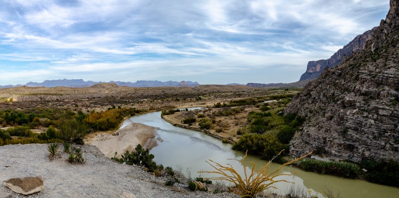
The name Big Bend refers to the macro scale 90 degree turn in the Rio Grande River in the park; however, despite the name, the bend in the river isn’t really what you visit the park to see. To even recognize it as a bend, you’d almost have to be in the air above it.

This is what the name Big Bend refers to.
The park has so many other sights to see, though. It protects part of the Chihuahuan Desert, the second largest desert in North America. It includes the Chisos Mountains, the southernmost mountain range in the United States and the only one entirely contained within a National Park. And of course, there is the Rio Grande River which flows over 100 miles through the park, carving (3!) spectacular canyons.
The park elevation ranges from 1800’ at the river to over 7800’ in the mountains. Between the elevation changes and the mountain, desert, and river ecosystems, there are over 1200 species of plants and 500 species of animals. There are ruins from old ranches, and the park has some of the darkest skies in the country.

Ruins from the historic Sam Nail Ranch

Night skies. I took this while Sushila was doing a 6 am meeting in the visitor center parking lot, so there’s a bit more light pollution than normal.
Big Bend National Park has many backcountry campsites. Most are accessible with an off-road vehicle, but a handful are even accessible for a large RV like ours. We really hoped to get one, but unfortunately, we visited during busy season, and all of the sites that would have fit us were occupied. Instead, we had to camp at the Rio Grande Village Campground.
We were a little bummed at first. Rio Grande Village is still located within the park, but it’s on the far eastern side, about 45 mins from the main visitor center, Panther Junction. There’s no cell reception at all there, and we had a couple very early mornings driving all the way to the visitor center for wifi and work meetings. In the end, though, camping there ended up being pretty great.

View of our campground from a nearby overlook
The campground itself was fine but nothing to write home about. The eastern side of the park, though, was awesome. The Sierra del Carmen mountains, located in Mexico, border the eastern edge of the park. The range rises almost a mile above the surrounding terrain, with peaks close to 9000’. When you first see them, it’s hard to believe they are even mountains. We didn’t even notice them at first; we assumed they were just clouds on the horizon. When Sushila realized they were mountains, I even argued with her that they weren’t. That’s how crazy they are. When it’s not cloudy, they are positioned perfectly for the evening sunlight, and they look amazing. Driving back to the campground each day with that view was enough to make it worth it.

The drive approaching the eastern side of the park at sunset

The Sierra del Carmen mountains at sunset
The eastern side of the park is also where the Hot Springs are located. At one time, a settlement and spa were located on the site, but only a few old structures remain. The springs are still accessible, though, and are a must-see in the park. The water stays a perfect 105 degrees year round, and if you need to cool off, you can step over the pool wall and into the Rio Grande River, which flows directly alongside the hot spring. Camping a few miles from the hot springs made it an easy trip to enjoy the water at sunset.

Hot springs!

Hot springs along side the Rio Grande River.
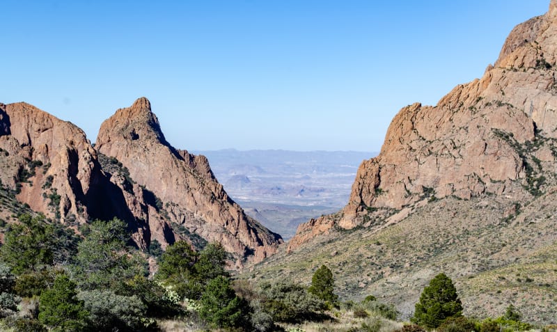
Big Bend National Park is a geologic wonderland. The park includes Mariscal Mountain, the southernmost expression of the Rocky Mountains in the United States, and part of the Ouachita Mountains, which run east-west and are considered an extension of the Appalachian Mountains. It includes the Chisos Mountains, formed by volcanic activity over 30 million years ago, and it includes limestone formed when North America had an inland sea stretching from the Arctic Ocean to the Gulf of Mexico, covering Texas.
Along the western side of the park, the Ross Maxwell Scenic Drive runs south-west from the base of the Chisos Mountains to the Rio Grande River. The drive was designed by Ross Maxwell, a geologist and the park’s first superintendent, who wanted to highlight many of the geologic features in the park.

A view of the western side of the Chisos Mountains

Panoramic views from Sotol Vista

Goat Mountain along the Ross Maxwell Scenic Drive
The drive provides great views of the Chisos Mountains, Goat Mountain, Mules Ears peaks, and many others. The Sotol Vista overlook provides an amazing view of the entire western side of the park, and it is a great spot to watch the sun set. The road also runs past the Castolon Historic District, a cavalry outpost in the early 1900s that now serves as a visitor center with historic buildings and displays.

Sushila checking out Mules Ears peaks in the distance

An historic building in the Castolon district

Sunset from Sotol Vista
The Ross Maxwell Scenic Drive ends at Santa Elena Canyon. It’s one of three canyons in the park that are carved by the Rio Grande River. There’s a great little hike that leads you back into the canyon, and it was one of my favorite things in the park. The limestone walls tower 1500’ above you on either side (one in Mexico, one in the US), and it was really amazing to see.

The mouth of Santa Elena Canyon. One of my favorite views in the park.
The view back at the park from inside the canyon.
In the center of the park are the Chisos Mountains. They are the southernmost mountains in the United States, and they’re also the only range contained entirely within a national park. They were formed over 30 million years ago, when Big Bend was host to a series of volcanic eruptions. They stand like an island in the center of the park, towering over the surrounding desert. The highest peak is over 7800’. The increased elevation, along with double the rainfall of the surrounding area, create a forest ecosystem that would seem more at home in the mountains of Colorado than the desert of Texas.

The eastern side of the Chisos Mountain Range

Driving up into the Chisos Basin
The Chisos Basin is located in the center of the mountain range. It’s the location for one of the park’s visitor centers, a campground and lodge, and many of the park’s most popular hikes. One of the most iconic views from the basin is that of The Window. It’s a gap in the basin walls where water and sediment can escape, and there are extensive views through the gap to the southwestern desert below.
The Window
There’s a trail that leads all the way to The Window. We were about to hike it when we met another couple, regulars in the park, that strongly suggested doing the Lost Mine Trail instead. We turned around and headed that direction, and it did not disappoint. The trail climbs the eastern side of the basin, and for the majority of the hike, you have amazing views back into the Chisos Basin. When you finally reach the top of the trail, you’re treated to incredible views across Pine Canyon and Juniper Canyon to the south-eastern end of the mountain range.

Views from the top of Lost Mine Trail looking east

Sushila taking in the view
If you visit the area, I also have to recommend the South Rim trail. It’s a long, challenging day hike, and we didn’t have the time to do it, but everyone said it has the best views in the park. If you can, definitely check it out.
Davis Mountains State Park
We left Big Bend and continued heading west. We were aiming for Guadalupe Mountains and Carlsbad Caverns National Parks, but we stopped at Davis Mountains State Park for a weekend on our way. It’s a great little park nestled in a valley, and it happened to be just down the road from a ranch that Sushila used to visit each summer when she was a kid.

Panoramic view of the Davis Mountains
It’s a pretty area, and there are some good hikes in the mountains, but the main reason we stopped was to visit the nearby McDonald Observatory. Bonus - they were having a Star Party on the weekend we were there.

Star party!
The observatory is part of the University of Texas at Austin, and it’s one of the world’s leading centers for astronomical research. It’s home to one of the world’s largest optical telescopes, and there are many others that are smaller but still very impressive. They’re also part of the team working on the Giant Magellan Telescope which will be the world’s largest telescope with 10x the power of the Hubble Telescope.

A few of the telescopes we were able to use

The Milky Way!
Of course, you don’t actually get to use all of the biggest telescopes there, but they still had some very impressive ones set up for the guests to view through. They were far larger than any others we’ve used at other astronomy events we’ve attended (large enough to need the fixed domes to cover them since they can’t easily be moved). We got to observe the Andromeda Galaxy, a young and old star cluster, and a couple nebulae.

The beautiful night sky

The Milky Way!
Fort Davis National Historic Site is located right next to the state park, so we also stopped in to check that out while we were nearby. It’s one of the best surviving examples of an Indian Wars’ frontier military post in the Southwest. It protected emigrants, mail coaches, and freight wagons traveling along the San Antonio-El Paso Road.

Fort Davis National Historic Site

Fort Davis National Historic Site
Carlsbad Caverns National Park
On our way out of Texas, we stopped to visit Carlsbad Caverns National Park and Guadalupe Mountains National Park. The two parks are about 30 mins apart, and they’re both part of the same overall geologic formation - the Capitan Reef. Back when Pangaea was still a thing, New Mexico and Texas were along the coast near the equator, and a small inland sea covered the area. A large reef formed in that sea, and it’s visible today in these two parks.

Carlsbad Caverns National Park
At Carlsbad Caverns, you explore inside the ancient reef. At the moment, there are 119 known caves within the park, and there are over 300 known throughout the surrounding area. They include some of the largest and longest caves in the world. In particular, the caves here are known for their exceptionally large rooms.

A model of the main cave at Carlsbad Caverns

The entrance to the cave. Earlier in the season, you’d be able to watch bats fly out every night. The cave was discovered when a rancher mistook the bats for smoke.

Looking back up at the entrance. This was only about a quarter of the way down.
It’s really hard to convey a sense of scale when taking pictures of the caverns. The best I could do was to try to capture some handrails from the walking paths in the distance, but you can barely even see them in the full-size versions of the pictures. For all of the individual formations I’m showing, they are significantly larger than a person. In some cases, it would be better to compare them to a bus or a house. They’re massive. I’ve only been in a few different caves, but they always had tight, narrow passages, and the “big” rooms in them were maybe the size of a large room in a home. The Big Room in Carlsbad could fit the US Capitol Building. Twice. With room to spare. It really was incredible to see.

It’s hard to see, but right near the middle of the picture is a distant handrail. I was standing about halfway through the room when I took this.
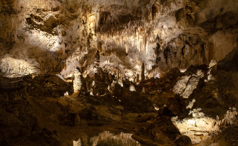
Another huge room in the cave
In addition to the scale, the number of cave formations was also hard to believe. The cave was completely covered, and they were beautiful. The cave includes popcorn formations, which we also saw at Wind Cave, and the usual stalactites, stalagmites, and columns that you associate with caves. Our favorite formations were the draperies, though. They form when water drips down a sloped ceiling, and the flowy, cloth-like structures look awesome!

A really cool drapery formation
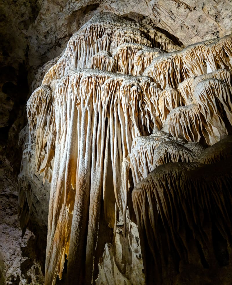
One of my favorite formations in the cave

This one gives a good sense of scale

Popcorn!

Another massive cave formation
Guadalupe Mountains National Park
I didn’t even know Guadalupe Mountains National Park existed prior to starting our trip. I only realized it was there because I was planning our stop at Carlsbad Caverns and noticed another place labeled “National Park” right next door. Oops.

Guadalupe Mountains National Park

Our campsite in the park. It was basically just a parking lot, but the views weren’t too bad.

We had great dark skies in the campground
The park protects the world’s most extensive ancient fossil reef. It formed while North America was still part of Pangaea. The area was originally covered by an inland sea, but as the sea receded and sediment covered the area, the reef was fossilized. More recently, due to continental movements, the area was uplifted thousands of feet, exposing the reef. The four highest mountain peaks in Texas are part of this range.

Guadalupe Peak
The highest peak, Guadalupe Peak, was a pretty strenuous hike. We chickened out and decided to take the easier hike (and more scenic, since it was a cloudy day and we wouldn’t have had views from the peak). We hiked through McKittrick Canyon. When the fall colors are in full force, the canyon has been described as the most beautiful place in Texas. Unfortunately, we missed the peak of the colors by a couple weeks, but it was still a great hike.

The entrance to McKittrick Canyon

A wash along the McKittrick Canyon Trail
Most of the hike follows a dry river bed, starting at the mouth of the canyon and winding its way back in. A few miles in, we stopped at Pratt Cabin, built by the original owner of the land who later donated it to the park. It was a cute little cabin, and we enjoyed a picnic lunch at the spot. After lunch, we continued up the trail to The Grotto. It’s a small cave in the side of a limestone cliff, and it looked crazy. The structures in the cave actually look like a reef formation, but in reality, they are stalactites and stalagmites that form as water moves slowly through the rock. The limestone is from the ancient reef, though.

The Grotto

Hiking further along the trail
White Sands National Monument
After over a month in Texas, we finally moved on to New Mexico. We were in a bit of a rush since we needed to be in Phoenix to catch flights for the holidays, but we made time to stop at White Sands National Monument on our way through.

Mango enjoyed the sand at our campsite

We had beautiful sunsets boondocking along Holloman Lake
White Sands National Monument is one of those places that’s hard to believe when you see it. It’s the largest gypsum sand dune field in the world. When the sun is out, the sand is almost blindingly white. The dunes aren’t nearly as high as those at Great Sand Dunes National Park, but you won’t care. The stark white color is incredible.

The dunes aren’t very tall, but they are bright white and stretch on into the distance.
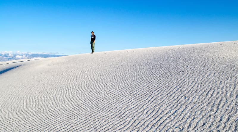
The sand was damp and formed really cool ripples from the wind
Normally, I’d imagine the sand is pretty dry (it is, after all, a desert). We visited after two days of rain, though, so the sand was still pretty damp. It wasn’t great if you were hoping to have that soft, sand-between-your-toes feeling, but on the plus side, it is way easier to walk across damp, hard-packed sand. Another benefit - you can build sandcastles!

Sandcastles in the sand

Sushila preferred poo mounds over castles
We were lucky to be in the area at the same time as our new friends, Meag and Mollie of @thestepvandiary. We spent a few days boondocking together nearby, and we got to spend the day at White Sands together. We brought some snacks, set up our chairs, enjoyed the warm sun, and played in the sand. It was basically a day at the beach, minus the water.

Walking out into the dunes

Our spot among the dunes

Mollie had always wanted to be burried in the sand
Tucson, Arizona
We also saved a few days to stop in Tucson, Arizona, to visit Saguaro National Park. The park protects the saguaro cactus, one of the most iconic features of the American Southwest. They are also exclusive to the region - they only grow naturally in a limited section of the Sonoran desert. The cacti are surprisingly long-lived; they don’t even start to grow their characteristic arms until they’re over 75 years old, and many live to be over 150 years old. They regularly grow over 40 feet tall, and the tallest ever known was almost 80 feet tall.

Saguaro National Park

The Saguaro cacti were pretty tall

Hiking around the park
The saguaro cactus is certainly the most prominent in the park; however, the park is home to more than 1200 different plant species. We took a great little hike out through the desert, and we were surprised at the diversity of plant life we encountered, even in the very small section of the park we visited. The park is also home to quite a few animal species. We weren’t around long enough to see very many, but we heard packs of coyotes in the early evening, and we were lucky enough to catch a ferruginous hawk enjoying a meal on top of a cactus.

Checking out the cacti up close

Another cactus

The internal structure of a dead cactus

A ferruginous hawk enjoying a meal
We also spent a day at the Arizona-Sonora Desert Museum. It’s very close to the western part of Saguaro National Park, and it’s absolutely worth a stop if you’re nearby. It showcases many of the plants and animals of the region and is rated as one of the top zoological museums in the country.

Some cool cacti

Mango’s cousins. Also known as Bobcats.

An Ocelot

Hummingbirds!

Hummingbirds!
We also attended two raptor shows at the museum. The viewing area was right in the middle of the flight zone, and you had a great view of the birds.

A ferruginous hawk

An owl

Another hawk
Holidays
We parked the RV in Phoenix and flew back to Pennsylvania to visit Will’s family for the holidays. We were traveling too long to leave the cats alone, and I don’t think they would have been happy being boarded (plus the cost was higher than the plane tickets), so we brought them with us. It was our first time flying with both of cats. It was a pretty big hassle - I can’t imagine flying with kids - but they did well on the plane and were happy to arrive in a familiar place in PA.

The kitties made it back to PA for Christmas!
It’s amazing what a difference 6 months has made for the cats. While we were at my parents’ house prepping the RV, the cats refused to go outside. We could carry them out, but they would struggle and fight, and as soon as we’d put them down, they’d run back to the house as quickly as possible.
Now the cats will run out the door on their own (with or without their harnesses!) if we aren’t careful. They’re very comfortable outside, and they’ll walk all around the property. They’re also great with their leashes; a gentle tug is usually enough to get them walking in the direction we want. If they see a bird or find a really interesting smell, they still ignore us, but for the most part, they’ll actually walk with us.

The kitties adventuring in PA

Mango says he was never scared of the outside. He was just pretending before.
Of course, they’re still cats, and they also enjoyed plenty of time napping on the couch and under the Christmas tree.

Mango loved this spot
I still wouldn’t call them full-fledged adventure cats - Mango is startled pretty easily, and Ollie tends to follow behind me rather than lead the way - but they’re getting closer.
We also made a quick trip back to New York City to visit friends. It was great to see everyone again, and there were some moments that made me miss being in the city, but I’m definitely not ready to go back.

Hanging out with some of our NYC friends
We enjoyed the trip home, but after two weeks, we were ready to get back to the RV and keep moving.

We took some family photos while we were home

They didn’t all turn out perfectly
Xscapers
We flew back to Arizona just in time for the Xscapers New Year’s Eve Convergence in Quartzsite, Arizona. Xscapers, a subset of the larger Escapee’s organization, is a group of working-age and/or young-at-heart RVers. It serves as a support network for education and information you might need for working and traveling full-time, but more importantly, it serves as a community for like-minded travelers. The club organizes meetups (aka convergences) throughout the year and around the country for RVers to gather and spend time together.
We hadn’t originally planned to attend the New Year’s Eve convergence, but plane tickets were a bit cheaper and more convenient for flying back to Arizona before NYE, so we decided to go. What was intended to be a small, informal gathering ended up with over 200 people gathered in the desert.

Arial shot of our camp in Quartzsite, Arizona. Photo credit: Jason Smith
We’re so glad we went! It was far and away the best New Year’s Eve party I’ve ever attended. The official event was only a few days long, but we stayed for over a week (and many were still there when we left). It was a week filled with new friends, games, off-roading, potlucks, and bonfires. We drank at an off-grid bar in the desert, celebrated birthdays, and gazed at the stars. It was a wonderful way to start the new year.

An off-grid bar in the desert

A group of Xscapers hanging out at the desert bar

Playing with fire

Making a long fire is a great way to keep a large group warm

The group from an off-roading trip.
After 8 days of boondocking at New Year’s Eve, we had a few days to recharge, and then it was off to the Xscapers Annual Bash. This is the biggest event of the year, and over 500 RVers attended. We gathered in Lake Havasu City, Arizona, and it was another 8 days of fun and festivities!

A lot of RVs packed in at the rodeo grounds in Lake Havasu City, Arizona
There was a bloody mary bar and a margarita throwdown. We had a mac & cheese fest, potlucks, food trucks, and BBQ. We played board games and old-school Nintendo games. We drove off-road, drank by the fire, and danced to the music. We ended the event with a rave and the most ridiculous music setup I’ve ever seen.
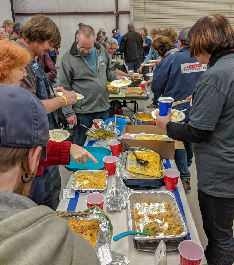
Mac & Cheese potluck

Game night included Mario Kart on the Wii

An off-road trip in the area

Fire and a dance party

The Rave Rover. It was actually drivable and played music for the party on the final night.
I had high expectations going into the Bash. I’d seen pictures and heard stories from previous years, and those were only amplified talking to all of the seasoned Xscapers at New Year’s Eve. I was almost worried I’d be disappointed since it was so built up, but the event completely surpassed what I expected.

The party on the final night of the event
The thing that surprised me most, though, was how quickly friendships formed and grew. People we met just a few weeks ago now feel like life-long friends. After the bash ended, we weren’t ready to say goodbye yet, so a smaller group of us found a nearby boondocking spot and spent the week together.
That final week included a trip to Oatman, a small town in the Black Mountains of Arizona along historic Route 66. You can take the highway into town, but we opted for the back, off-road route in. It was a fun drive, and we arrived in town just in time for an old-west style shoot-out on the streets. It started as a mining town, but now it caters to tourists. The town is also famous for the wild burros that roam the streets.

Off-roading to Oatman with Cassie and Matt

A shoot-out on the streets of Oatman! It might be a bit touristy.

Cassie petting a burro
A few people that wanted to visit the town weren’t able to make the first trip, so we planned a second. Only a short way into the drive, though, our friend Matt blew two of his tires on a sharp rock. It was a bit stressful at the time since he only carries one spare, but luckily, a second truck was with us and their spare had the same bolt pattern. It wasn’t actually the same size tire, but it was enough to limp back home. The trip didn’t turn out quite as planned, but in hindsight, we still had a pretty good time. It was also a good way to learn that Discount Tire’s insurance program is worth the money!

Repairing one of the two flat tires

Not the worst spot in the world to have to stop
Up Next
In the next “Catch Up” post, we visit Mexico, explore Joshua Tree National Park, take friends to the Grand Canyon, and boondock near Las Vegas!